Challenge icon

We would like to quickly assess weather-related risks for flight missions

For determining the feasibility of helicopter and small aircraft operations, it is necessary to check weather risks that affect flight missions, such as low clouds and poor visibility over the planned flight route or area. However, it can be difficult to accurately grasp weather risks that affect flight missions using only weather charts or general weather forecasts.

Available solutions

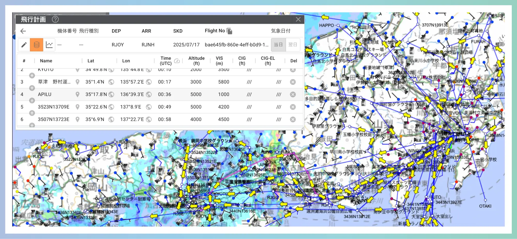
Weathernews' GO or NO GO Area Decision Support Service

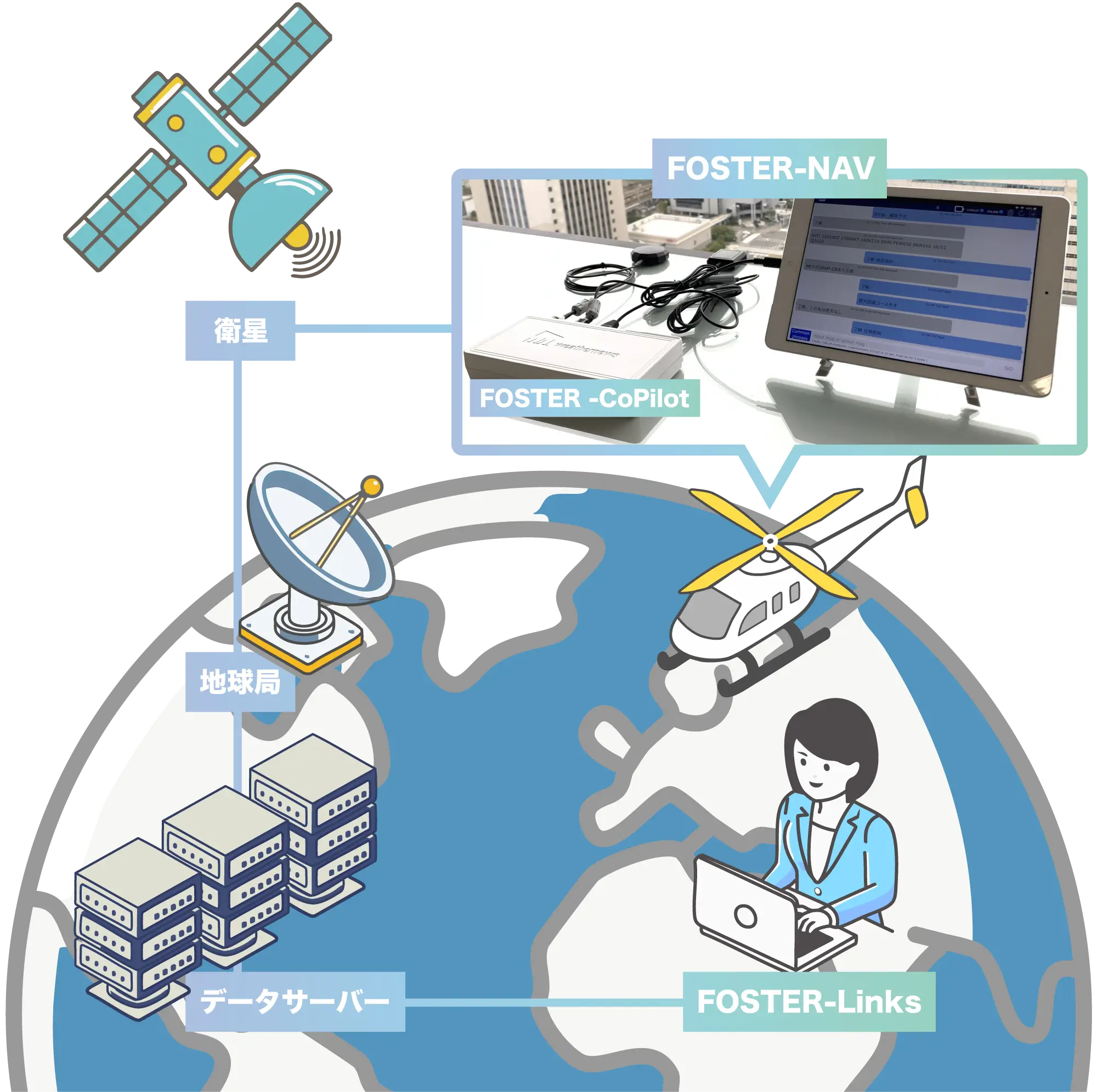
FOSTER-Links provides proprietary decision-support content to help you make timely and accurate operational calls.

Key Benefits

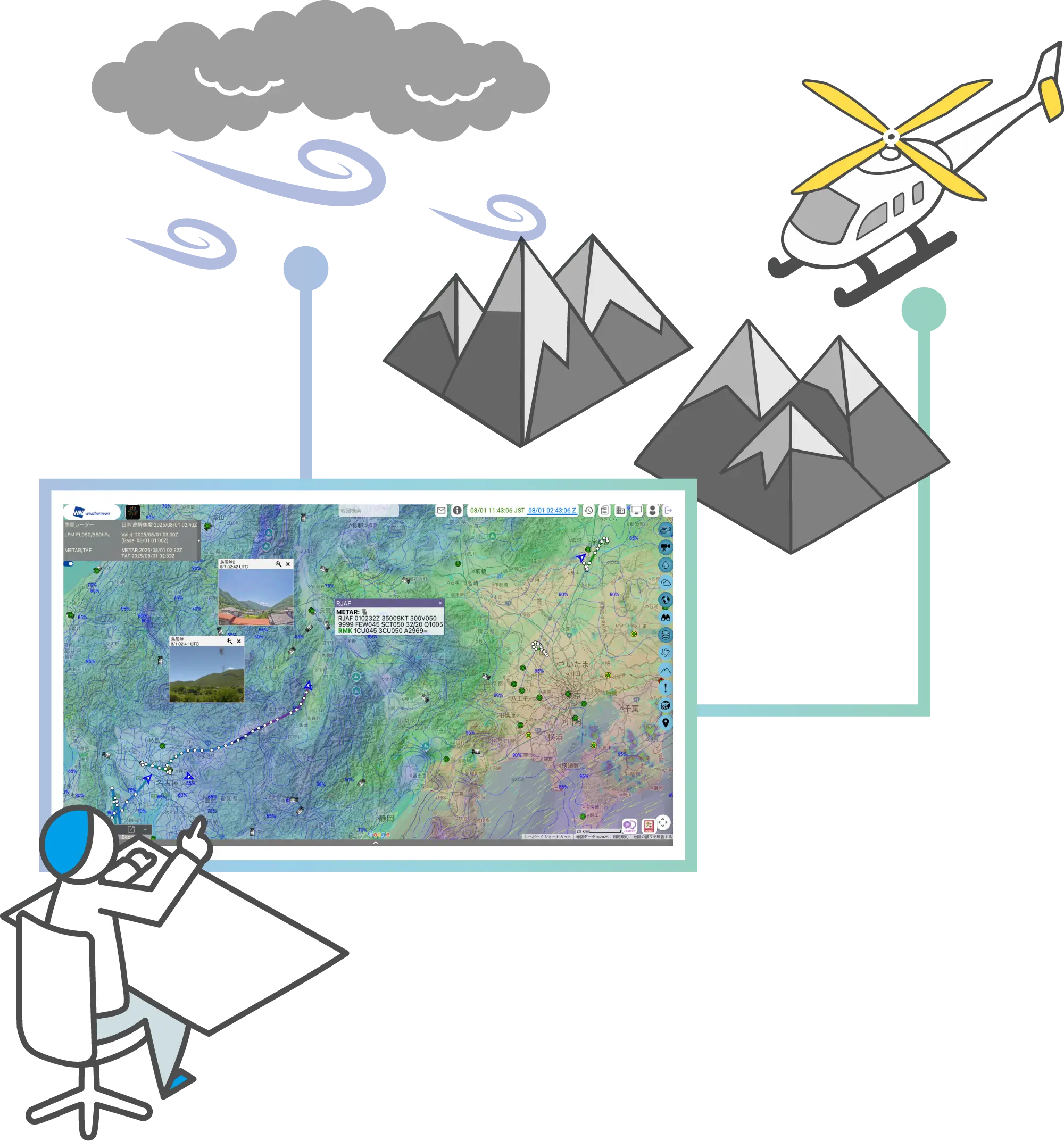
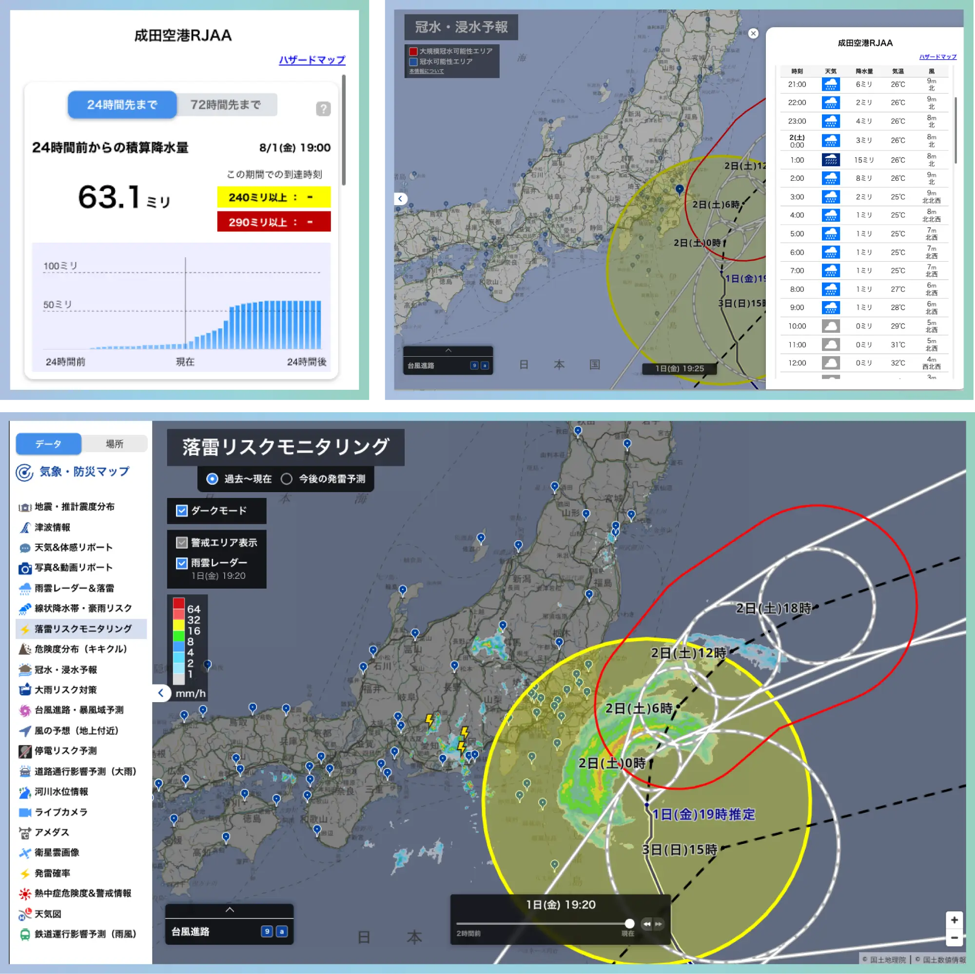
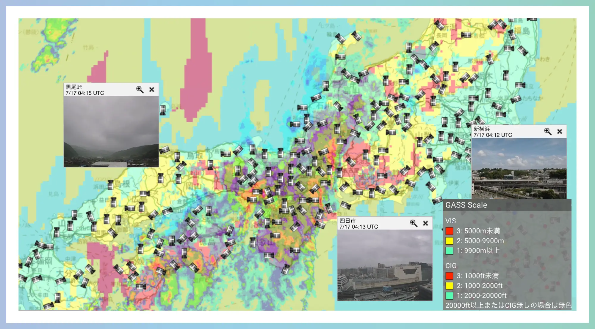
Visualizing areas of potential flight disruption

Areas with the potential to become IMC (Instrument Meteorological Conditions) are determined based on Visibility and Ceiling criteria and displayed on a map.
It is also possible to evaluate risks based on the amount of clouds that may exist below flight altitude. Additionally, we have established over 900 live camera images showing the conditions at major mountain passes nationwide, allowing real-time confirmation of sky conditions.

Key Benefits

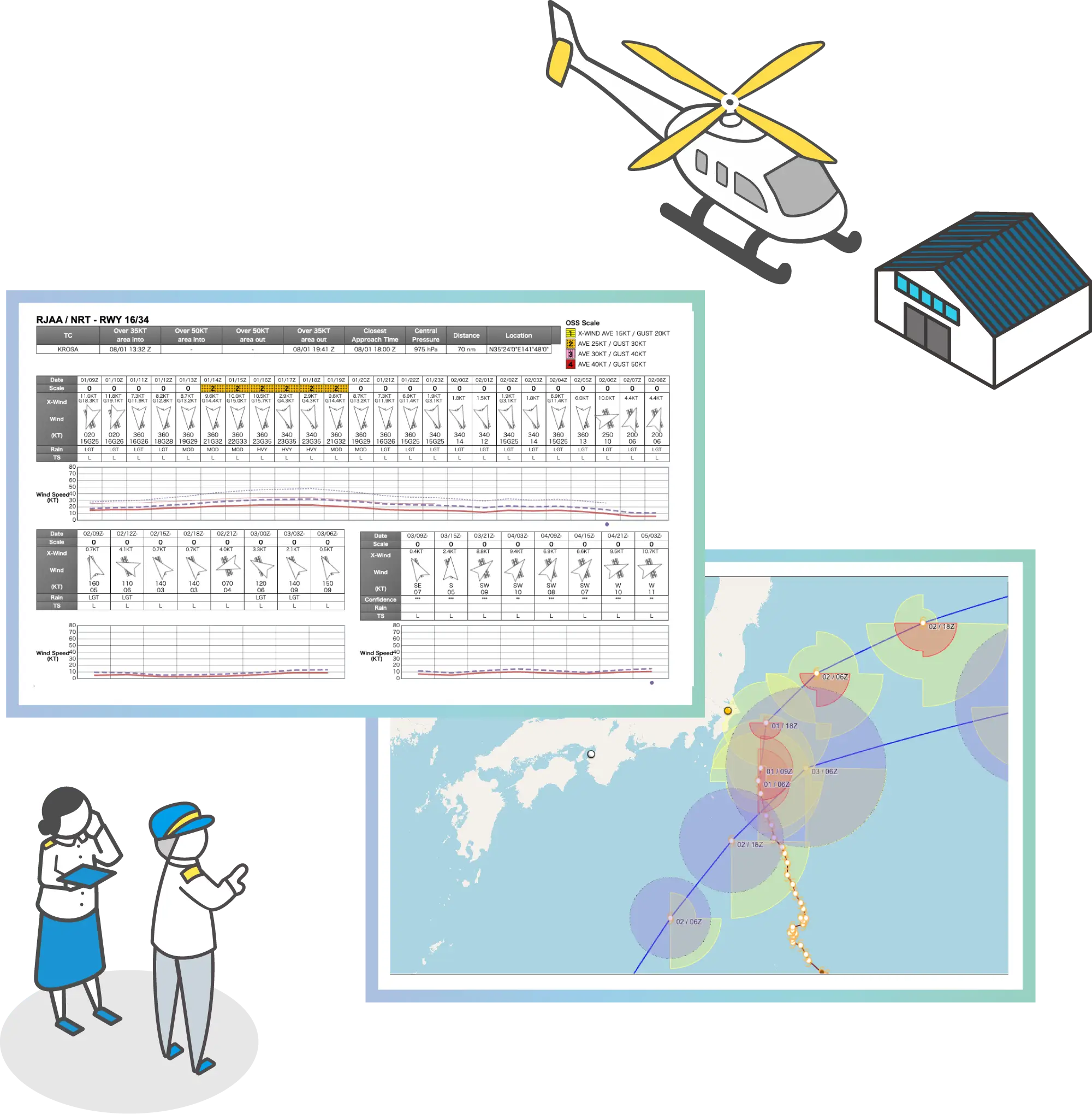
Visualizing weather risks along the flight route

You can easily set any desired route and view cross-sectional weather forecasts along that route to identify potential flight risks.
Based on the forecast data, alternative routes can also be selected.

understanding weather risks in low-altitude airspace concerns
- Contact us for details

Challenge icon

We would like to monitor aircraft flight status in real-time, even over mountainous areas as well as offshore.

Flight monitoring during flight presents challenges in mountainous areas and over oceans where radio communication is not available. Additionally, many flight tracking systems require aircraft modifications, which incurs high costs. Weathernews supports real-time flight monitoring through satellite links with the portable flight tracking system 'FOSTER-CoPilot'.

Available solutions

Weathernews’ Aircraft Tracker System

By linking a dedicated website with a proprietary flight tracking system, flight operations information can be centrally managed. This sensor uses Iridium satellite communication to track aircraft position and displays it overlaid with weather information, achieving more robust safety management. Furthermore, text chat with onboard tablets is also possible through the dedicated website.

Key Benefits

Supporting safe flight monitoring by overlaying essential aviation weather with flight data.

Radar, lightning data, METAR/TAF, and key camera feeds can be pinned on screen to support monitoring.
Each user’s screen layout can be saved and quickly loaded upon the next login.

Key Benefits

Portable Movement Management System: FOSTER-CoPilot

The portable flight tracking system 'FOSTER-CoPilot' acquires aircraft position information in real time through Iridium satellite communication.
Position information obtained from the aircraft is displayed on monitoring tools for ground flight operations managers and can be overlaid with weather information for use in operational decision-making.

Key Benefits

Consolidating all the information you need to see

By connecting an iPad to the fleet management system 'FOSTER-CoPilot,' text chat communication with ground control becomes possible through a dedicated app.

your flight management concerns
- Contact us for details

Challenge icon

We would like to know the best timing for aircraft evacuation during typhoon approaches.

Typhoon impacts may require moving aircraft to hangars. Since weekly forecasts are insufficient, early grasp of affected areas and duration is essential for planning.

Available solutions

Weathernews Aircraft Evacuation Support Service

Based on weather forecasts up to 96 hours ahead, we visualize time periods when aircraft may be at risk, supporting swift evacuation decision-making.

Key Benefits

Want to check typhoon impact on your airport ahead

Provides typhoon track forecasts from multiple meteorological agencies and displays projected wind impacts on designated airports up to 96 hours in advance. Enables preemptive assessment of diversion or aircraft relocation needs several days prior to typhoon arrival.

typhoon-related operational impacts concerns
- Contact us for details

Challenge icon

We would like to assess risks to employee safety or operational bases during severe weather events

When typhoons, heavy rain, or snowstorms occur, ensuring employee safety and enabling swift response become critical.

Available solutions

Weathernews' BCP/BCM Support Services

To ensure business continuity and employee safety, we provide advance notification when severe weather events are forecasted.

Key Benefits

Assessing Flood and Disaster Risks at Airports and Heliports

Accurate information on future weather conditions is essential for decisions such as 'How long can flight operations continue?' and 'By when should safety measures be implemented?'
By utilizing Weathernews’ flood, inundation, and cumulative rainfall forecasts, you can pinpoint risks at each site, optimizing business uptime while ensuring employee safety.

Recommended Solutions for BCP/BCM Support

Weathernews for business

BCP/BCM concerns
- Contact us for details

Aviation Weather Latest News

Analysis of Aviation Meteorological Elements at Kaohsiung International Airport (RCKH/KHH)

April 16, 2026

Potential Formation of a New Tropical Cyclone — Outlook Based on Conditions Near Guam, MJO Activity, and ENSO Trends

April 7, 2026

Surging Fuel Prices Hit Airline Operations

April 2, 2026

Analysis of Aviation Meteorological Elements at São Paulo/Guarulhos International Airport (SBGR/GRU)

March 31, 2026

Opening the Door to the North American Market — Insights Brought Back from Miami

March 24, 2026

Widespread Unseasonal Early Heatwave Across the US West Coast This Week

March 18, 2026

The Yellow Dust Season Arrives — Spring Sand and Dust Transport Threatens Flight Operations

March 5, 2026

Dubai International Airport (OMDB/DXB) — Late Winter to Early Summer Weather Characteristics

March 2, 2026

Wind Characteristics and Operational Strategies at Narita International Airport (RJAA/NRT)

February 25, 2026

Heavy Snow and Strong Winds to Impact the Eastern US; Widespread Severe Weather Expected from Feb. 20

February 20, 2026

Cherry Blossom Forecasts × Inbound Demand — Value Beyond Operations

February 17, 2026

Winter Storm to Bring Widespread Snow and Low Visibility to Europe Through Feb 15

February 13, 2026

Phuket International Airport (VTSP/HKT): Seasonal Thunderstorm Risk and Operational Measures

February 10, 2026

Meteorological Characteristics of Radiation Fog at Delhi Airport (VIDP/DEL)

February 3, 2026

Winter storms continue to impact the US, as record-breaking bitter cold affects flights

January 29, 2026

Meteorological Background of the Complex Track of Tropical Storm No. 1 “Nokaen” East of the Philippines

January 27, 2026

Winter Storms Raise Risk of US Flight Disruptions, Jan 23–26

January 22, 2026

Severe Winter Storms Strike in Succession — Speed of Decision-Making is Key to Aviation Operations

January 19, 2026