















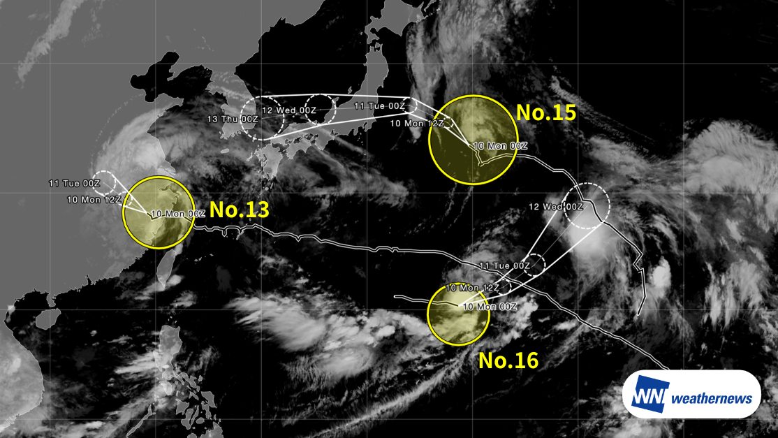
Typhoon Dolphin (No. 13) – Current Status
According to the Japan Meteorological Agency (JMA), as of 09:00 JST on August 10, Typhoon Dolphin (No. 13) was located over central China (28.3°N, 119.2°E), moving northwest at 6 kt. The central pressure was 985 hPa, with maximum sustained winds of 45 kt and maximum gusts of 65 kt.
Landfall Update and Forecast
Typhoon Dolphin made its first landfall near Yuhuan, Taizhou City, Zhejiang Province, China, around 17:30 (China Standard Time) on August 9, then made a second landfall near Yueqing, Wenzhou City, around 18:40. At landfall, it was a very strong typhoon with maximum sustained winds of 82 kt.
The storm is expected to continue moving northwest while weakening rapidly, transitioning into a tropical depression. Through August 11, strong winds are expected along the coast of East China, over the East China Sea, and around Taiwan, with heavy to very heavy rain likely, mainly across East China.
Typhoon Chan-hom (No. 15) – Current Status
According to JMA, as of 09:00 JST on August 10, Typhoon Chan-hom (No. 15) was located east of Japan (33.8°N, 149.7°E), moving northwest at 9 kt. The central pressure was 990 hPa, with maximum sustained winds of 40 kt and maximum gusts of 60 kt.
Forecast
Chan-hom is expected to intensify slightly while moving northwest and then west, and is forecast to make landfall near Ibaraki or Fukushima Prefecture on the afternoon of August 11. Heavy rain, strong winds, and high waves are possible, mainly along the Pacific side of the Tohoku and Kanto regions.
Typhoon Peilou (No. 16) – Current Status
According to JMA, as of 09:00 JST on August 10, Typhoon Peilou (No. 16) was located near the waters off Minami-Torishima (20.3°N, 148.7°E), moving east at 19 kt. The central pressure was 998 hPa, with maximum sustained winds of 35 kt and maximum gusts of 50 kt.
Forecast
Peilou is expected to move east and then northeast, moving away from the Ogasawara Islands. Little to no direct impact on land areas is expected.
Important Notes
Significant uncertainty remains regarding the storm's future development and exact track. Conditions may continue to change, so please keep checking the latest forecasts.
For more timely and detailed information on typhoons and tropical disturbances, please visit SkyAviators, our decision-support tool for aviation operators. We encourage you to use it to keep track of future developments. Learn more about "SkyAviators"
This article is provided for reference purposes only. Specific operational support for individual flights is available exclusively through our paid services for aviation operators. Weathernews Inc. accepts no responsibility for any operational decisions made based on this article, or for any losses or damages resulting therefrom.
![[Tropical Depression] Forecasted to Become Typhoon DUJUAN – Expected to Approach Japan as a "Strong" System](https://gvs.weathernews.jp/wxtech_cms/typhoon25_dujuan_cover_de9913c666.png)