















Current Situation
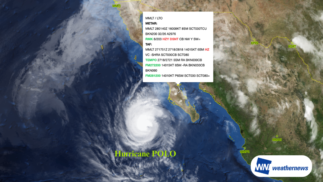
According to information released by the National Oceanic and Atmospheric Administration (NOAA), as of 00Z on September 28, 2026 (UTC), Hurricane POLO was located approximately 435 km west of Cabo San Lucas, Mexico (22.4°N, 114.1°W), moving north at approximately 19 km/h (10 kt). The central pressure is 951 hPa, with maximum sustained winds near the center reaching approximately 110 kt.
Outlook
POLO is forecast to track northward before turning northeastward, crossing the Baja California Peninsula through September 29, and moving across the Gulf of California toward mainland Mexico. It is expected to gradually weaken and diminish to a tropical depression by September 30.
Specifically, the storm is forecast to reach the waters west of the Baja California Peninsula around 12Z on September 28, and cross the peninsula to its eastern side around 00Z on September 29. Continuing its northeastward track, it is expected to cross the Gulf of California and approach mainland Mexico around 12Z on September 29.
Maximum sustained winds are expected to be around 100 kt at 12Z on September 28 and 95 kt at 00Z on September 29, weakening to about 60 kt by 12Z on September 29, and further dropping to around 25 kt by 00Z on September 30.
Forecast for Loreto International Airport (MMLT/LTO)
Loreto International Airport (MMLT/LTO) is located in Loreto, Baja California Sur, in northwestern Mexico, on the eastern coast of the Baja California Peninsula facing the Gulf of California. Serving as the primary gateway to Loreto, it operates both domestic and international flights.
Hurricane POLO is expected to pass to the north of MMLT Airport, making its closest approach locally during the night of September 28. The airport is forecast to enter the 35 kt wind radius. Southerly winds may exceed 30 kt from 21Z on September 28 to 09Z on September 29, with strong winds exceeding 40 kt possible particularly between 00Z and 08Z on September 29.
Looking Ahead
Hurricane track, intensity, and wind speed forecasts at the time of closest approach may change. Please continue to monitor the latest typhoon information, airport forecasts, and operational updates.
For more timely and detailed information on typhoons and tropical disturbances, please visit SkyAviators, the aviation decision-support tool for airline operators. Learn more about "SkyAviators"
Disclaimer
This article is provided for informational purposes only. Flight-specific operational support information is provided exclusively through our commercial services for aviation operators. Weathernews Inc. assumes no liability whatsoever for operational decisions made based on this article, or for any losses or damages arising therefrom.
![[Tropical Depression] Forecasted to Become Typhoon DUJUAN – Expected to Approach Japan as a "Strong" System](https://gvs.weathernews.jp/wxtech_cms/typhoon25_dujuan_cover_de9913c666.png)