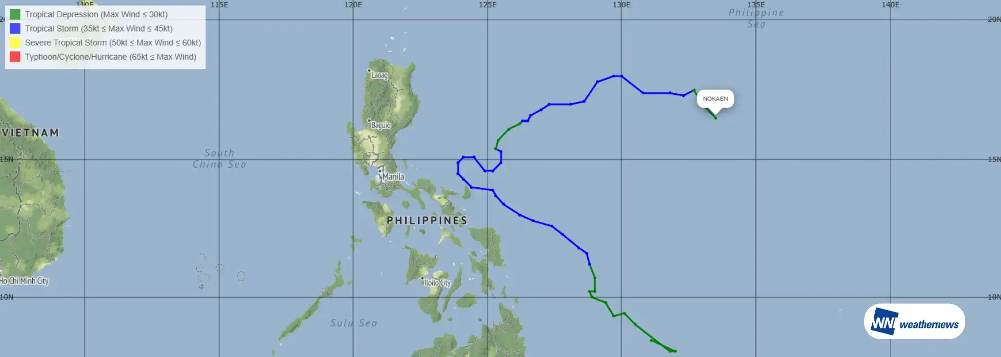
On January 15, 2026, Tropical Storm No. 1“Nokaen,” the first named system of the year, formed over the ocean east of the Philippines. Tropical storm formations in January are relatively rare in the western North Pacific. East of the Philippines, Nokaen followed a complex track—initially moving northwestward, then turning northward and eastward, and eventually transitioning into a tropical depression. What meteorological factors lay behind this unusual and complex movement?
Summary of Tropical Storm No. 1 “Nokaen”
According to the Japan Meteorological Agency (JMA) ASAS{su}* analysis, at around 06 UTC on January 15, a tropical depression located east of Mindanao Island, the Philippines, intensified into Tropical Storm No. 1 (NOKAEN). At the time of formation, the central pressure was 1000 hPa, with a maximum sustained wind speed near the center of 35 kt, moving northwestward at approximately 15 km/h.
The system gradually intensified thereafter; however, development remained limited. At its peak, the minimum central pressure reached 996 hPa, and the maximum sustained wind speed near the center increased to 40 kt, indicating no significant intensification. Around 00 UTC on January 21, Nokaen weakened and transitioned back into a tropical depression east of the Philippines.
*ASAS:Asia-Pacific Surface Analysis chart produced by the Japan Meteorological Agency
Overview of Tropical Storm No. 1 “Nokaen”
| Item | Tropical Storm ID | International Name | Name Meaning | Formation Date |
|---|---|---|---|---|
| Data | T202601 | NOKAEN | “Swallow” in Lao | January 15, 2026 |
What Determines the Track of a Tropical Cyclone?
The track of a tropical cyclone is governed by the interaction of multiple atmospheric factors.
Pressure Pattern: Highs and Lows A tropical cyclone is a type of low-pressure system and tends to move along the periphery of surrounding high-pressure systems. In particular, the Pacific subtropical high often acts as a “barrier” or a steering force, guiding tropical cyclones northward or pushing them along its edge.
Wind Flow Trade winds, which blow from east to west in low latitudes, tend to steer a tropical cyclone westward during its early stages of development. In contrast, the mid-latitude westerlies, including the jet stream, play a key role in turning a tropical cyclone eastward as it moves poleward.
Earth’s Rotation (Coriolis Force) Due to Earth’s rotation, a force acts to the right of the direction of motion in the Northern Hemisphere. As a result, tropical cyclones naturally tend to drift northward.
Influence of Land and Topography When a tropical cyclone makes landfall or interacts with mountainous terrain, its supply of warm, moist air—the system’s energy source—is disrupted. This can lead to weakening of the system or changes in its track.
In the present case, among these factors, the configuration of high- and low-pressure systems is considered to have played a primary role in influencing the tropical cyclone’s complex movement.
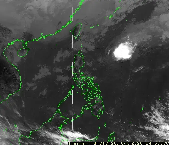
Source: Japan Meteorological Agency (Himawari Satellite, 04:50 UTC, January 20, 2026)
High- and Low-Pressure Patterns in the Case of Tropical Storm No. 1 “Nokaen”
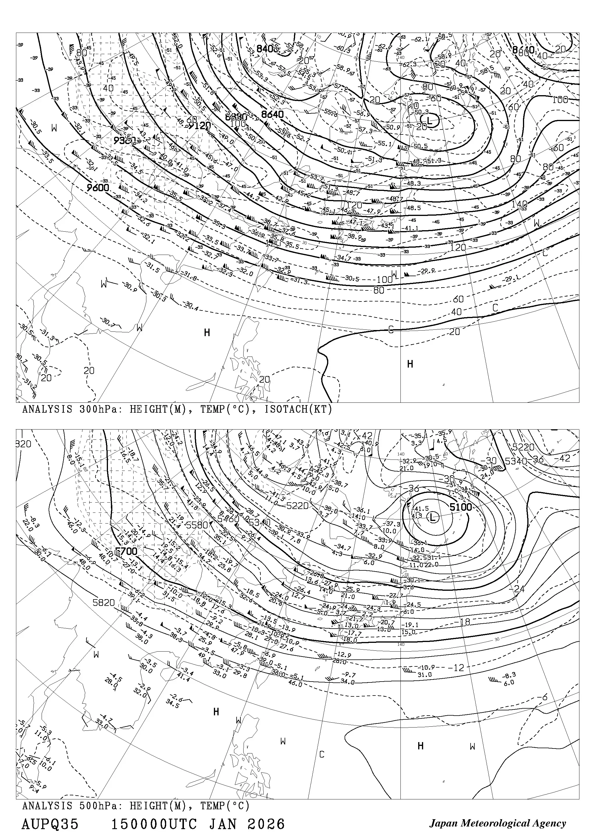
According to the 300 hPa upper-level analysis from JMA AUPQ35*, at 00 UTC on January 15, when Nokaen initially formed, high-pressure systems were present far to the east of the Philippines (northeast of the Nokaen) and to the west of the Philippines (northwest of the Nokaen). At that time, the high-pressure system to the northeast of Nokaen was dominant.
As a result, Nokaen moved northwestward along the periphery of the high, and this steering pattern persisted for some time.
After 12 UTC on January 17, the high to the northeast of Nokaen gradually retreated eastward, while the high to the northwest (west) became dominant. Under the influence of this high, Nokaen’s movement was blocked from the west to northwest, causing it to turn eastward.
In addition, by 00 UTC on January 19, a high-pressure system was also analyzed to the south of Nokaen. At this stage, Nokaen continued to move eastward along the edge of the surrounding high-pressure systems.
In this case, variations in the position and strength of surrounding high-pressure systems played a key role in producing Nokaen’s complex track.
Source: Japan Meteorological Agency