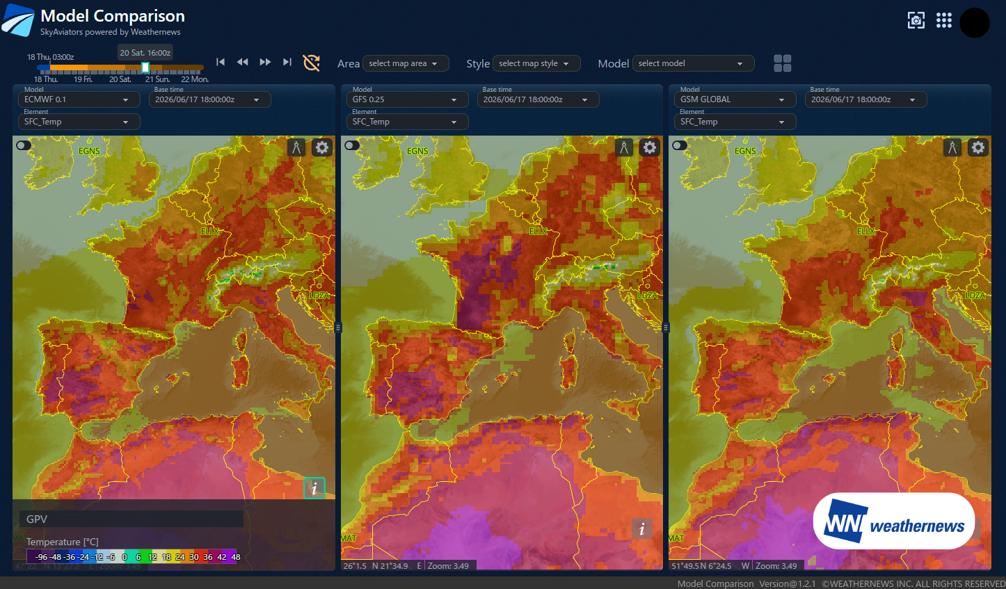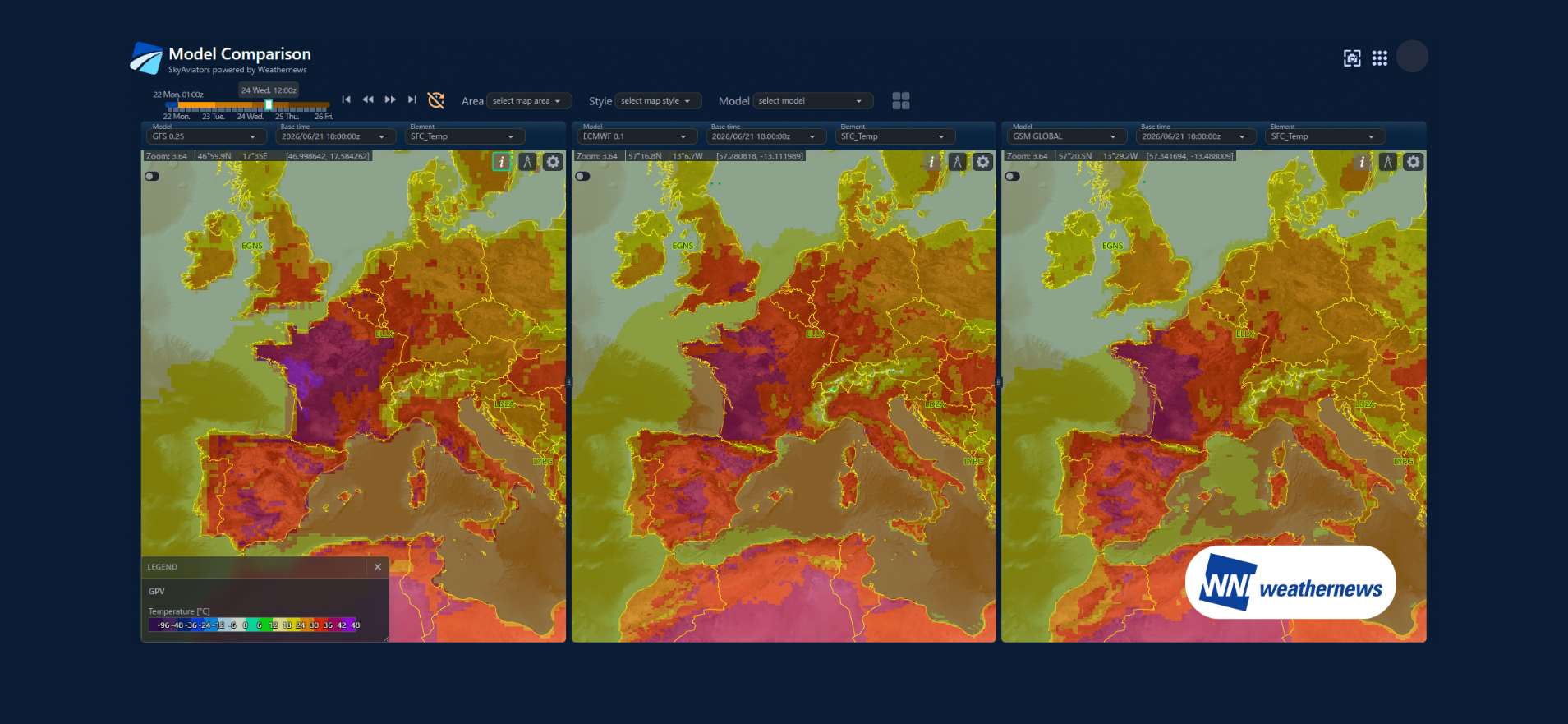
Due to the stagnation of the upper-level flow, a persistent high-pressure ridge remains anchored over Europe. As a result, temperatures are expected to climb even further throughout this week.
Key Drivers of the Record-Breaking Heatwave in Western Europe
- Heat Dome: A stagnant ridge acts as a lid, trapping a scorching air mass below.
- Subsidence: Sinking air within the high-pressure system continuously warms the atmospheric column 24 hours a day.
- Saharan Advection: Temperatures at the 850 hPa level are running +14 K above normal, with peaks reaching anomalies of ≥+18 K.
- Iberian Meseta Effect: The inland plateau is building a deep, dry mixed layer.
- No Atlantic Ventilation: Maritime cool air is completely shut out from entering the region.
- Dry Soil and Intense Sun: With no moisture to absorb heat through evaporation, solar radiation is converted directly into sensible heat, rapidly raising air temperatures.
- Dry Adiabatic Descent: As air sinks from 850 hPa to the surface, it warms by an additional ≥+10 K.
- Surface Super-Heating: Air immediately above the scorched ground is heated by another +3 to +5 K.
- Daily Accumulation: Warm daytime air lingers aloft through the night, leading to compounded heat buildup.
By the 24th, temperatures across Spain to northern France are expected to soar more than 12°C above average, resulting in extreme and dangerous heat. Forecasts also indicate that southern England will be engulfed by this hotter air mass.
Temperature Forecasts and Operational Risks for Major Airports on the 24th
In general, as the outside air temperature rises, air density decreases, which in turn reduces engine thrust during takeoff. Consequently, the maximum allowable takeoff weight is reduced. Therefore, cooler temperatures provide greater margins for takeoff.
However, when temperatures reach the upper 30s (°C) (specifically 36°C and above), the rate of thrust degradation accelerates sharply. Because of this, for aircraft and routes that typically operate near their maximum takeoff weight, such temperature spikes become a critical operational constraint. During extreme heatwaves like this, the impact on flight operations can expand to a much wider range of aircraft types and routes.
The temperature forecasts for the major capital airports on the 24th are as follows:
Country | Airport | Forecast (Daily Max / Min in UTC 00–24Z) |
|---|---|---|
| Spain | Adolfo Suárez Madrid–Barajas (LEMD / MAD) | Max 39°C / Min 25°C |
| France | Paris Charles de Gaulle (LFPG / CDG) | Max 41°C / Min 25°C |
Because Madrid is situated at an elevation of approximately 600 meters, its air density is inherently lower than at sea level. The addition of a blistering 39°C creates a dual challenge of "high temperature" and "high elevation." This combination can compromise aircraft takeoff performance significantly more than the same temperature would at a sea-level airport.
For detailed forecasts at airports worldwide, please visit "SkyAviators", our specialized decision-support tool for airline operators. Learn more about SkyAviators here