Current Status
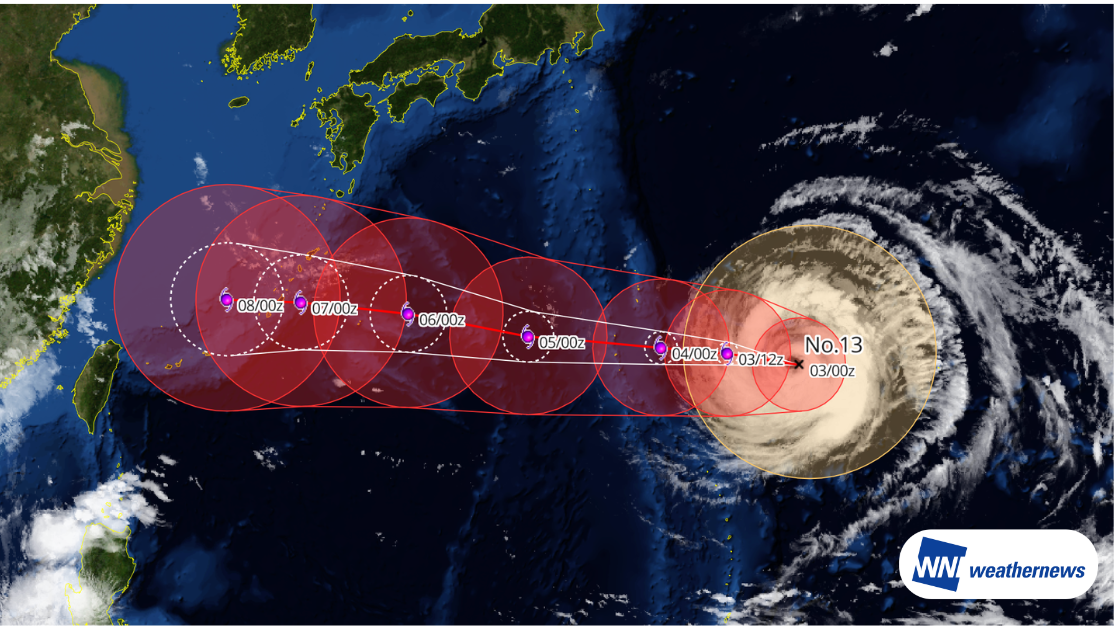
According to information released by the Japan Meteorological Agency (JMA) at 09:45 JST on August 3, 2026, Typhoon No. 13 DOLPHIN, currently classified as a very strong typhoon, was located over the waters near Minami-Torishima Island as of 09:00 JST on August 3 (24.4°N, 148.5°E), moving west-northwestward at 10 kt.
The central pressure was 945 hPa, with maximum sustained winds of 85 kt near the center and maximum gusts of 120 kt.
Forecast Track and Potential Impacts
Typhoon DOLPHIN is expected to maintain its very strong intensity through around August 6. The system will continue moving generally westward, passing south of Chichijima Island on August 4, and is forecast to approach the waters near Amami Oshima and Okinawa around August 7.
Heavy rainfall, strong winds, high waves, and other impacts are possible from the Ogasawara Islands through Kyushu and the Nansei Islands. In addition, moist air surrounding the typhoon and its outer rainbands could lead to widespread rainfall across areas from Kyushu to the Pacific side of the Kanto region, northern Taiwan, and the eastern coast of China.
Note
Significant uncertainty remains regarding the typhoon's further development and detailed track. Conditions are subject to change; please continue to monitor the latest weather forecasts.
More timely and detailed information on typhoons and tropical disturbances is available through SkyAviators, a decision-support tool for aviation operators. We encourage you to use it to stay up to date. Learn more about "SkyAviators"
Disclaimer
This article is provided for reference purposes only. Specific operational support information for individual flights is available exclusively through our paid services for aviation operators. Weathernews Inc. assumes no responsibility for any operational decisions made based on this article or for any losses or damages arising therefrom.
![[Tropical Depression] Forecasted to Become Typhoon DUJUAN – Expected to Approach Japan as a "Strong" System](https://gvs.weathernews.jp/wxtech_cms/typhoon25_dujuan_cover_de9913c666.png)