Current Typhoon Status
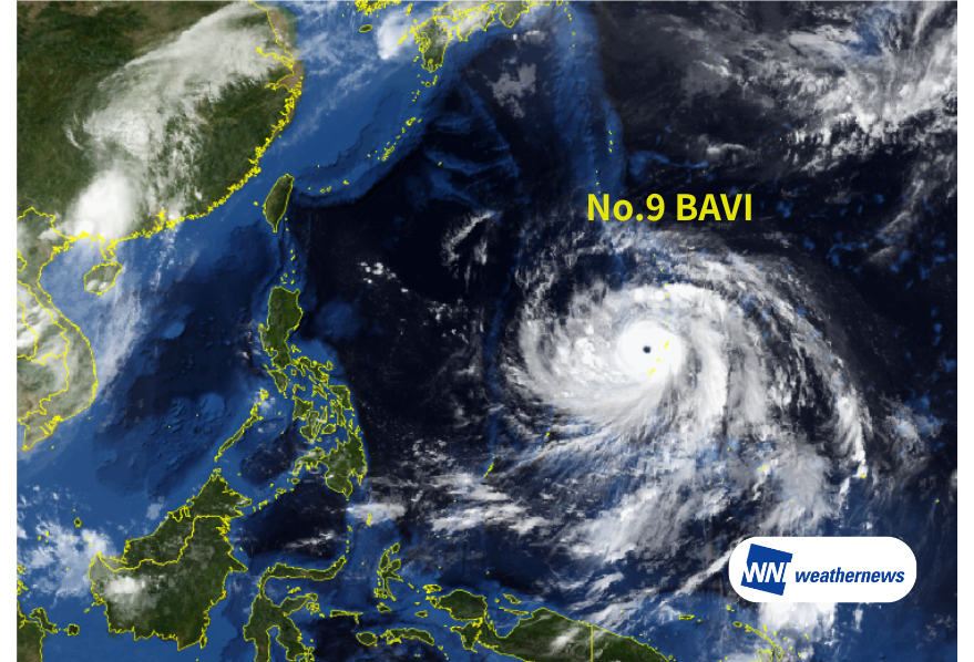
According to information issued by the Japan Meteorological Agency (JMA) at 12:45 JST on July 6, 2026, Typhoon No. 9 BAVI — a large, violent-intensity typhoon — is located near the Mariana Islands (14.6°N, 144.6°E) as of 12:00 JST on July 6, moving west-northwest at 10 kt. Central pressure is 910 hPa, with maximum sustained winds of 110 kt and peak gusts of 155 kt near the center.
Outlook for Impact Recovery at Saipan International Airport (PGSN/SPN)
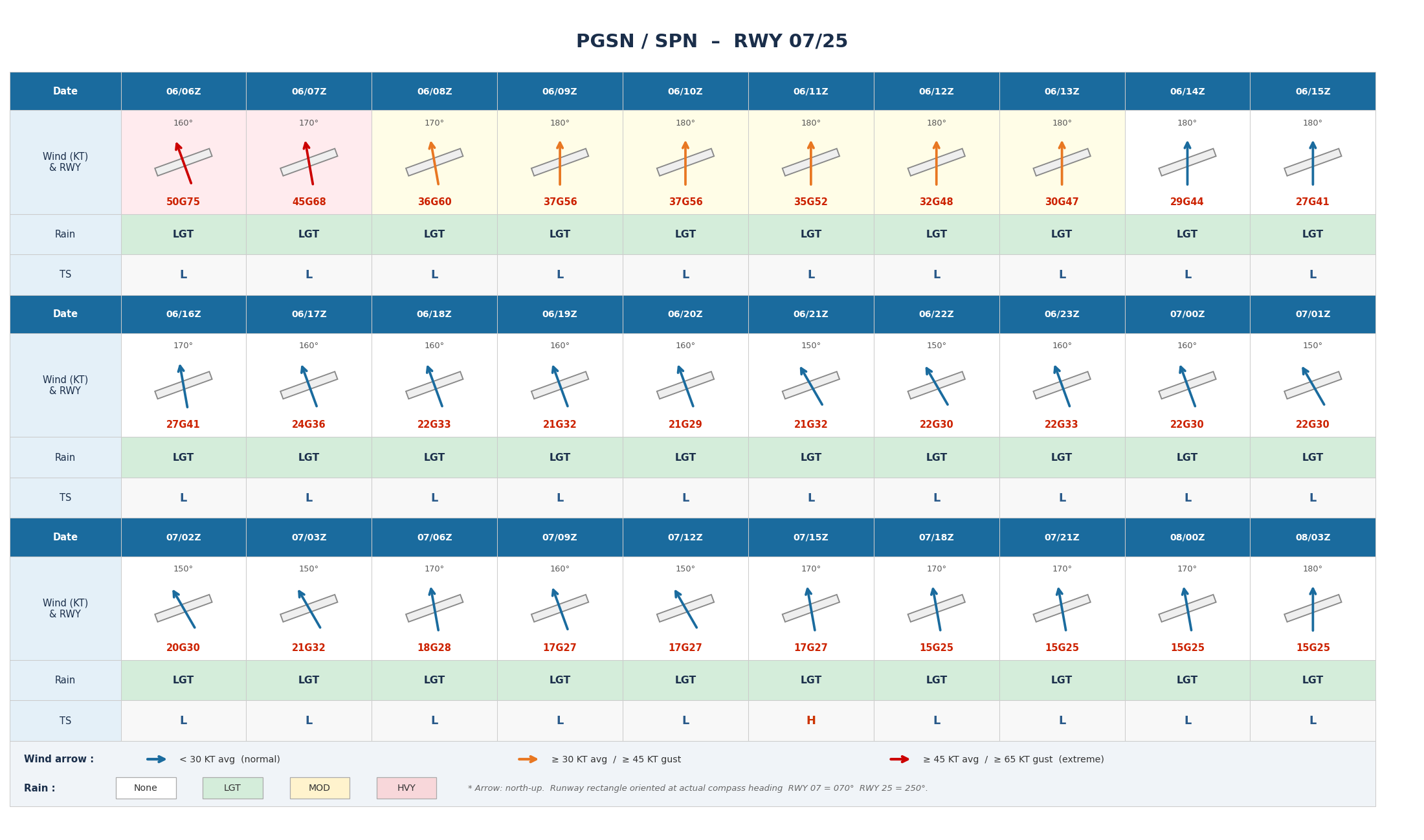
At Saipan International Airport (PGSN/SPN), peak impact is expected around 07Z on July 6 (all times UTC), with average winds reaching 50 KT and gusts up to 75 KT. Winds will gradually ease thereafter; however, average winds of approximately 30 KT with gusts near 45 KT are expected to persist until around 16Z on July 6, with the potential for continued disruption to flight operations. A rapid recovery is forecast from 17Z onward. Note that convective activity following typhoon passage may produce thunderstorms around 15Z on July 7.
Outlook for Impact Recovery at Guam International Airport (PGUM/GUM)
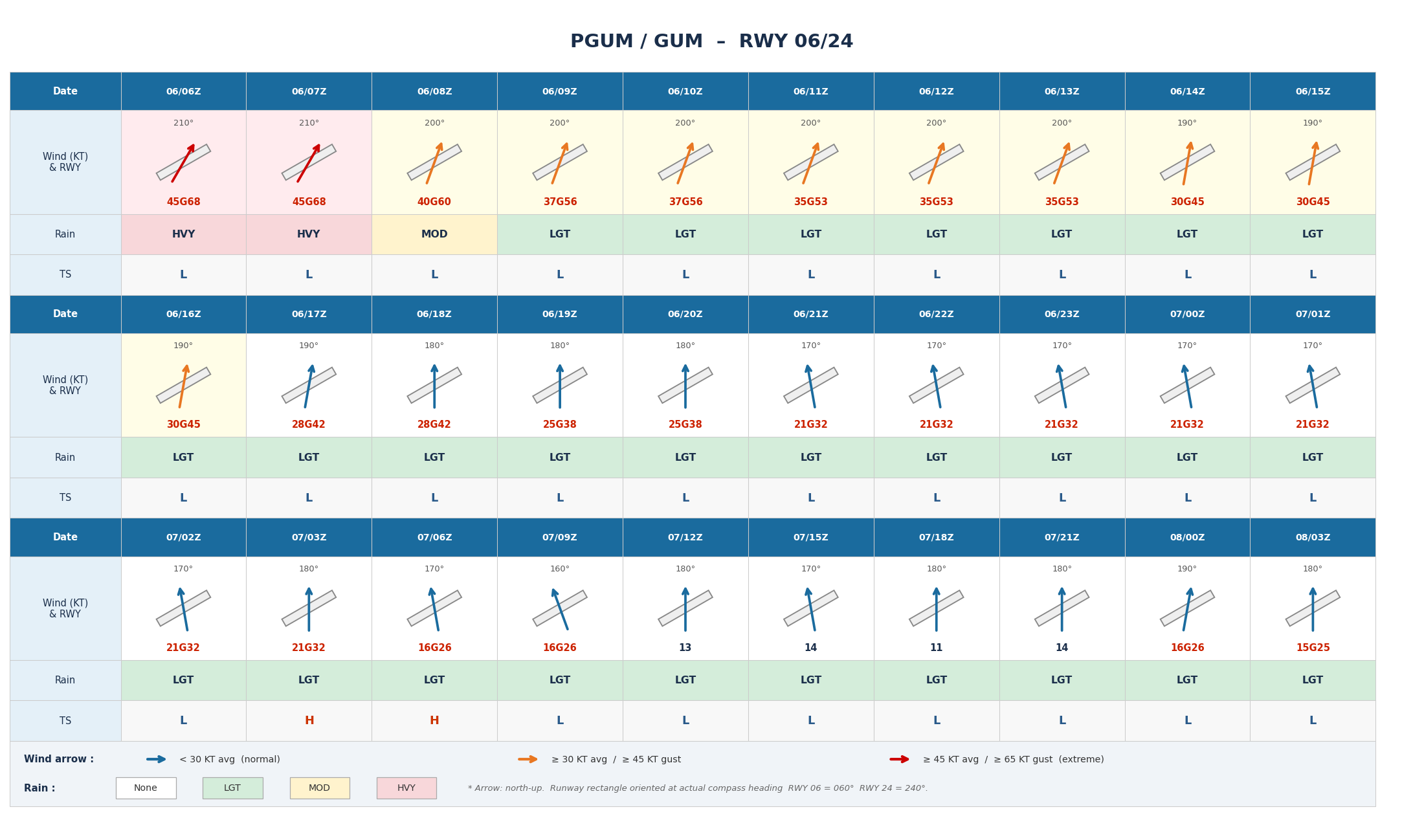
At Guam International Airport (PGUM/GUM), peak impact is expected around 07Z on July 6, combining very strong winds averaging 45 KT with gusts up to 68 KT and heavy rainfall. Winds and rain will begin to ease from 08Z onward; however, average winds of approximately 30 KT may persist until around 16Z on July 6, requiring continued caution for flight operations. Winds are forecast to gradually subside from around 17Z, with operations expected to recover thereafter. Note that convective activity following typhoon passage may produce thunderstorms around 03–06Z on July 7.
Future Track Outlook
The typhoon is forecast to continue moving westward and is expected to approach the Sakishima Islands at violent intensity on July 10. Heavy rain, violent winds, high waves, and storm surge are anticipated across the Nansei Islands, particularly in the Sakishima Islands. At Okinawa Island, please monitor changes in rainfall and wind conditions, especially around Naha Airport (ROAH/OKA).
Based on the current forecast track, the typhoon is then expected to turn west-northwest and approach northern Taiwan. Widespread precipitation is anticipated across Taiwan, with strengthening winds requiring particular attention in the northern regions. In the greater Taipei area, please monitor rainfall and wind changes around Taiwan Taoyuan International Airport (RCTP/TPE) and Taipei Songshan Airport (RCSS/TSA).
The forecast track, intensity, and wind speeds upon approach remain subject to change. Please continue to monitor the latest typhoon information, airport forecasts, and all operational updates.
For more timely and detailed typhoon and tropical disturbance information, please visit SkyAviators, our weather decision support tool for aviation operators. We encourage you to leverage it to track the latest developments. Learn more about "SkyAviators"
*This article is provided for reference purposes only. Specific operational support information for individual flights is provided exclusively through our paid services for aviation operators. Weathernews Inc. assumes no responsibility for any operational decisions made based on this article, or for any losses or damages arising therefrom.*