Large-scale wildfires broke out across Greece from late July 2026 onward. Weathernews Inc. (WNI) has estimated the socio-economic impact of these fires for the period from July 28 to mid-August, based on a scenario in which only publicly available weather data — from sources such as the Japan Meteorological Agency, the US GFS model and ECMWF — is used.
The resulting estimate is approximately JPY 21.8 billion (around EUR 134 million). This figure is not a confirmed damage total from any government or official authority; it is Weathernews’ own independent estimate.
Fires spread from Crete to Halkidiki
On July 29–30, 2026, a severe wildfire broke out in the Rethymno regional unit in southern Crete, killing two firefighters who were tackling the blaze. On the same day, a separate wildfire in the Peloponnese claimed the life of one more firefighter. Winds gusting up to 125 km/h (around 35 m/s) are reported to have hampered firefighting efforts, and the fire in Crete remained only partially contained as of July 31. Around 8,000 people are reported to have evacuated from the wider area, including the resort town of Agia Galini.
A new fire also broke out on Paros, and on July 31 the South Aegean islands were placed under wildfire risk Category 4 (Very High). The Attica regional unit near Athens was placed under Category 4 (Very High) on July 31 and Category 5 (Extreme) on August 14. On August 2, two firefighting helicopters collided in mid-air during operations there, killing both crew members.
On August 13, strong winds intensified a fire on the Kassandra peninsula (Sivili) in the northern Halkidiki region. According to the Hellenic Coast Guard, 481 people were evacuated by sea — 285 from Sivili beach to Sani, and a further 196 by high-speed boat to the port of Thessaloniki — with more than 200 firefighters deployed to the area. Greece's General Secretariat for Civil Protection reported 40 separate wildfires on August 13 alone, more than 500 since August 1, and around 2,700 since the start of the fire season on May 1.
Within the assessment period for this estimate (July 28 – August 16), seven fatalities have been confirmed: the two firefighters in Crete and one in the Peloponnese (all on July 29), the two helicopter crew in Attica (August 2), and an elderly couple who died on August 16. These seven deaths are presented here as background on the human toll of the disaster; they are not the basis for the human-impact figure calculated later in this report, which comes from a separate, population-level statistical model rather than a per-person count (see “Economic value of human impact” below). Separately, on July 1 — before the assessment period covered by this estimate — a father and son also died in a Greek wildfire; this is background information only and is not included in the calculation.
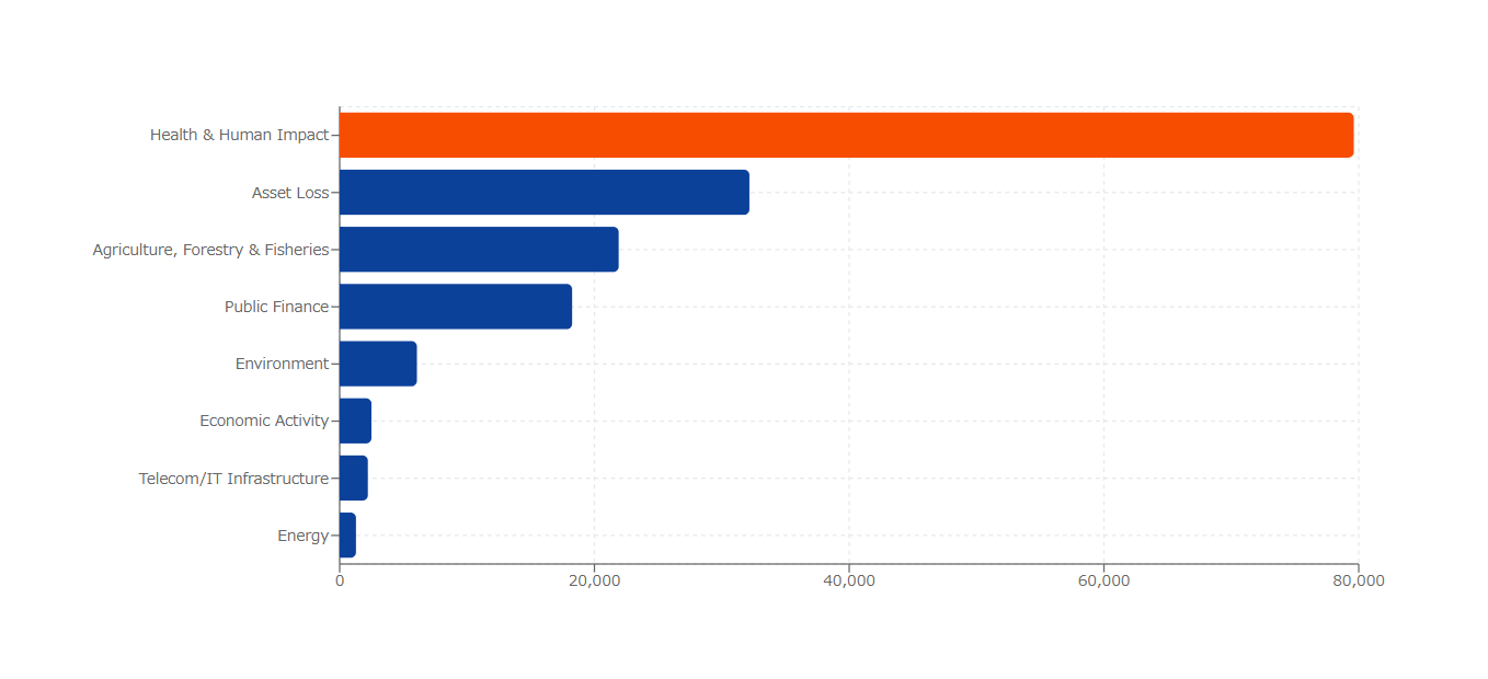
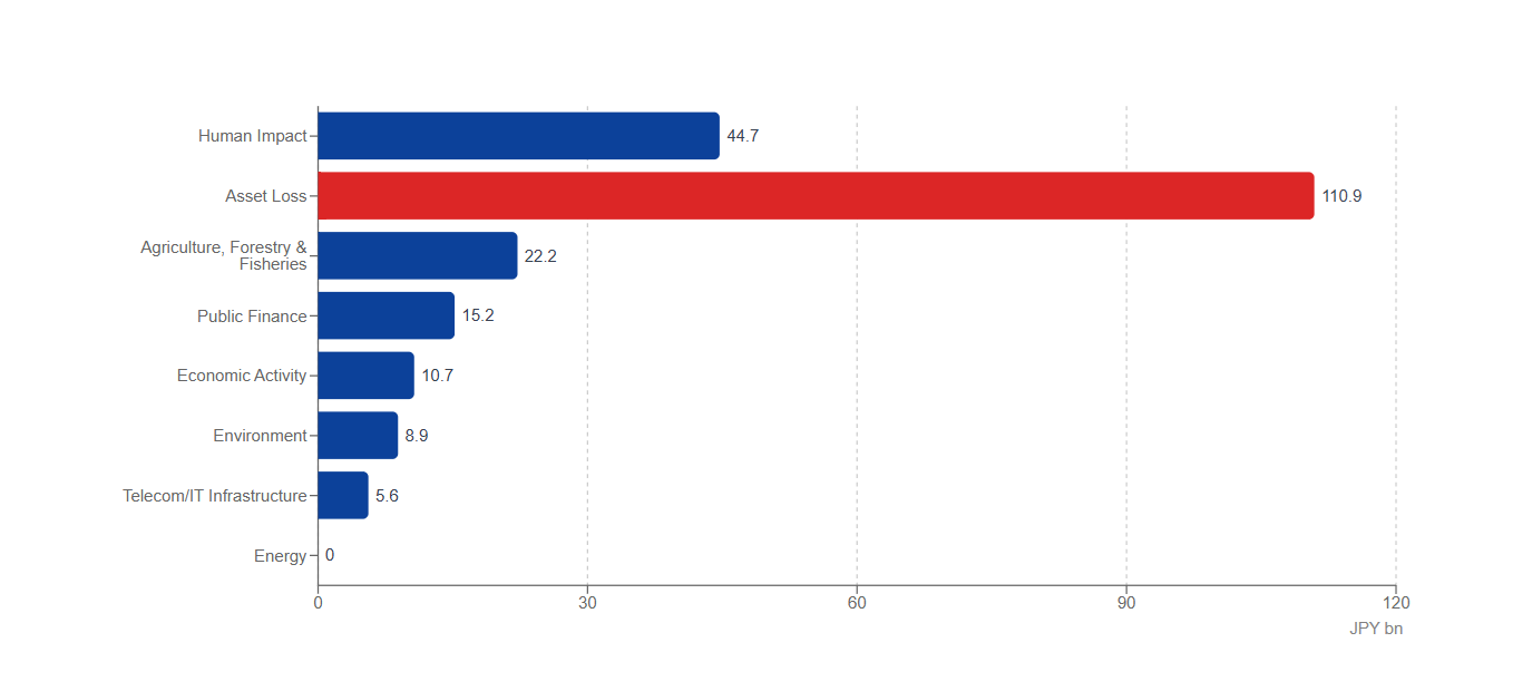
Asset loss accounts for half of the total: approx. JPY 11.1bn
According to Weathernews' estimates, of the total social and economic impact of approximately 21.8 billion yen (approximately 134 million euros), damage to housing, transportation infrastructure, and essential infrastructure (asset losses) accounted for approximately 11.1 billion yen (approximately 68 million euros, 50.8% of the total), making it the largest expense item. This asset loss is a top-down estimate based on the total value of buildings and infrastructure assets nationwide, calculated using the ratio of the burned area (over approximately 30,000 hectares according to reports) to the national land area, and construction cost indices. It is not a calculation based on actual measurements of individual burned buildings or asset unit prices. Damage to agricultural land is calculated under agriculture, forestry, and fisheries (separate category, approximately 2.2 billion yen), and damage to tourist facilities is calculated under economic activity (separate category, a portion of approximately 1.1 billion yen), and are therefore not included in this asset loss.
The economic value assessment of human impact is approximately 4.5 billion yen.
Human impact — the economic valuation of death, illness and reduced labor capacity — is estimated at approximately JPY 4.5 billion (around EUR 27 million, 20.5% of the total).
The majority of this, approximately JPY 4.0 billion (around EUR 24 million), reflects the rise in health risk from wildfire-related air pollution and heat, expressed as an increase in excess mortality across Greece's entire population and converted into economic value using the Value of Statistical Life (VSL).
This figure comes from a statistical model — used consistently across different types of hazards — that combines population, excess mortality rate, VSL and age-structure adjustments. It is not derived from, and should not be read as, a per-person valuation of the seven fatalities described above.
Impact on agriculture and tourism
Damage to agriculture, forestry & fisheries is estimated at approximately JPY 2.2 billion (around EUR 14 million, 10.2% of the total), and the impact on economic activity, including tourism, at approximately JPY 1.1 billion (around EUR 7 million, 4.9%). In areas under evacuation orders, tourist facilities and visitor numbers have also been affected.
mpact on public facilities and telecom infrastructure: approx. JPY 2.1bn
The impact on public finance — covering firefighting and evacuation response costs, along with post-disaster recovery of public facilities — is estimated at approximately JPY 1.5 billion (around EUR 9 million, 7.0% of the total). The impact on telecom/IT infrastructure, from severed communication lines and damaged base stations, is estimated at approximately JPY 0.6 billion (around EUR 3 million, 2.5%). Together with these two categories, the full set of cost categories — asset loss, human impact, agriculture/forestry/fisheries, economic activity, environment, public finance, and telecom/IT infrastructure — sums to the overall socio-economic impact of approximately JPY 21.8 billion.
Environmental impact: approx. JPY 0.9bn
Based on the reported burned area of 30,000+ hectares, the impact on the environment and forests is estimated at approximately JPY 0.9 billion (around EUR 6 million, 4.1% of the total). This valuation covers the existence value of forests and ecosystem services — supply, regulating and cultural services, including carbon sequestration and water-source purification — but excludes functions intrinsic to the soil itself, such as nutrient cycling, to avoid double-counting. Post-fire recovery and reforestation costs are instead counted separately, as part of the government response costs under Public Finance.
Why did the fires spread so extensively?
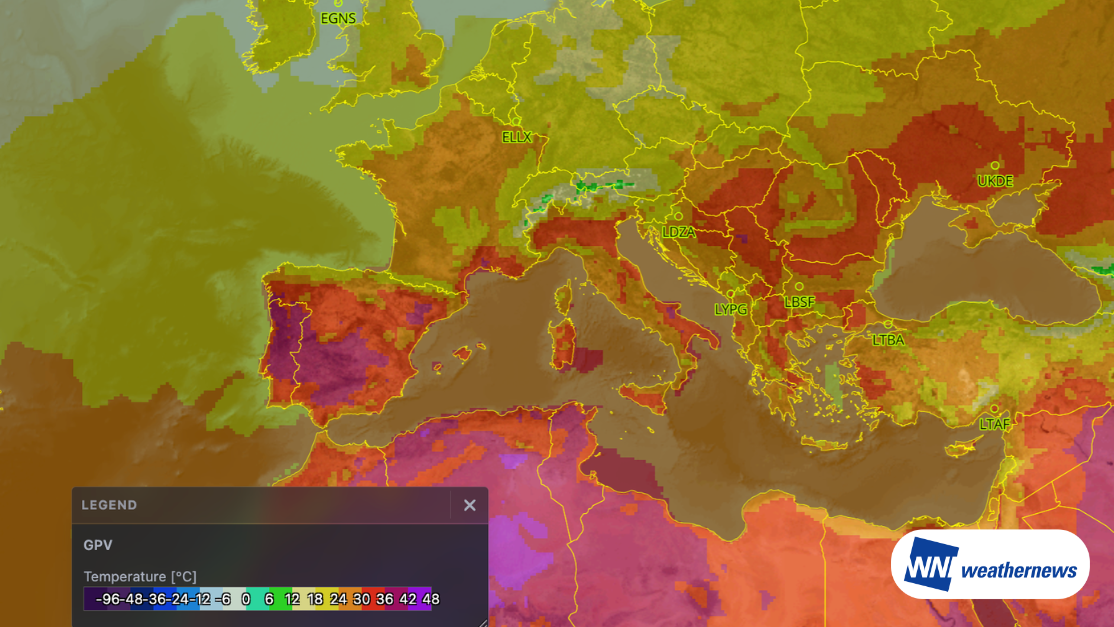
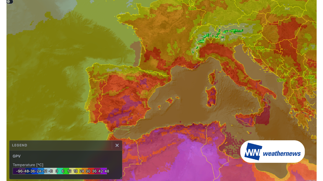
The causes of individual fires vary, but record-breaking heat and dryness, combined with repeated strong winds of up to 125 km/h (around 35 m/s), created conditions in which fires spread rapidly once ignited. Strong winds also hampered firefighting efforts. In addition, fires broke out at the same time in several regions — Crete, Paros, Attica and Halkidiki — requiring firefighting and evacuation resources to be deployed across a wide area at once.
Using weather information to help reduce damage
Using weather information to anticipate the strong winds and dry conditions that precede wildfires can support earlier decisions on firefighting resource deployment and evacuation timing, helping to reduce the resulting damage.
Basis of calculation and estimation method
This estimate was calculated using an economic value assessment model developed by Weathernews, drawing on weather observation data, population statistics and the Value of Statistical Life (VSL) for each cost category. Asset loss was approximated top-down, applying the ratio of burned area to national land area, combined with construction-cost indices, to the country's total building and infrastructure asset value.
Human impact is converted into economic value using a model based on population, excess mortality rate, VSL and age structure, rather than an estimate built from the actual number of fatalities — for this reason, the model-based valuation of human impact does not necessarily match confirmed casualty figures. Environmental impact covers forest existence value and ecosystem services, including regulating services such as carbon sequestration and water purification, and excludes the value of soil itself and recovery/reforestation costs, which are counted under Public Finance.
This estimate is not a confirmed damage figure from any official authority; it reflects Weathernews' own independent analysis.
Sources
Fire and evacuation information: Greece's General Secretariat for Civil Protection, Hellenic Coast Guard, Hellenic Fire Service, various media reports (July–August 2026)
Wildfire and burned-area statistics: multiple media reports citing EFFIS (European Forest Fire Information System / Copernicus). As of August 2026, Greece's nationwide burned area was reported at approximately 30,000–32,000 hectares; this estimate adopts the conservative lower bound of "30,000+ hectares."
Meteorological data: EMY (Hellenic National Meteorological Service)
Value of Statistical Life (VSL) reference: OECD
Damage assessment: Weathernews independent analysis (as of August 2026)
*This estimate reflects Weathernews' own independent analysis. It is not a confirmed damage figure. Preliminary report (as of August 27, 2026). Figures may change as official damage data becomes available.