Current Typhoon Status
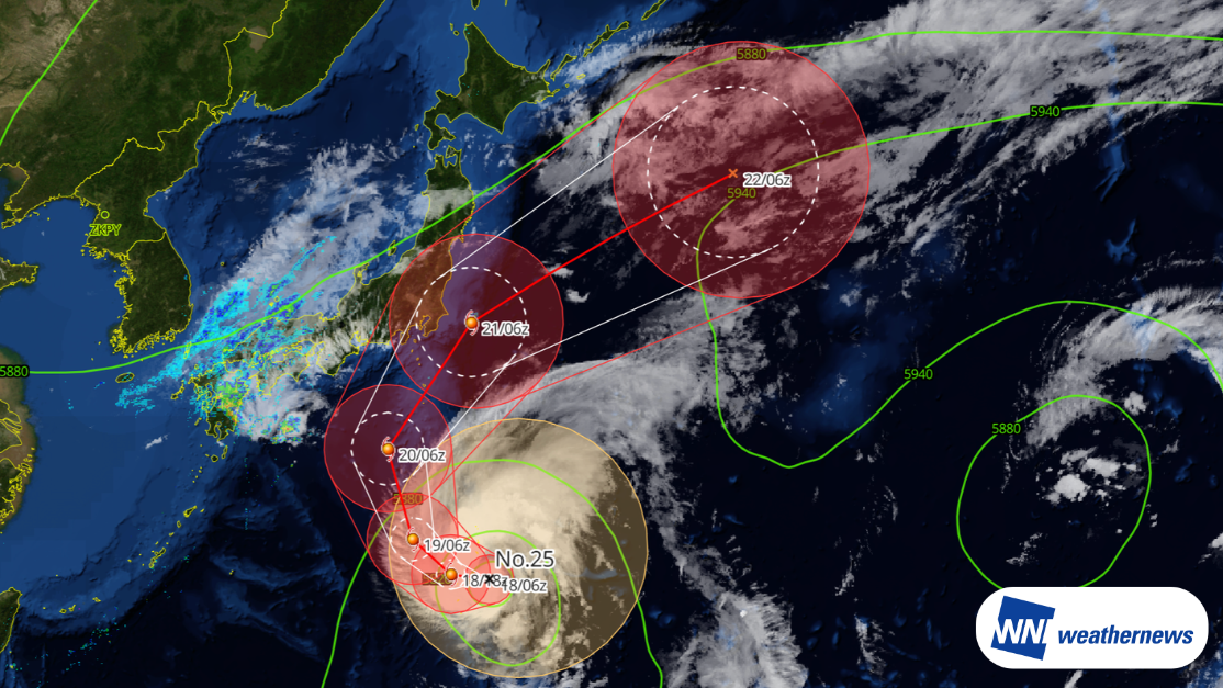
According to information released by the Japan Meteorological Agency (JMA) at 15:45 JST on September 18, 2026, Large Typhoon No. 25 (Dujuan) was located approximately 170 km south-southeast of Chichijima (25.6°N, 142.7°E) as of 15:00 JST on September 18, tracking west-northwest at 18 kt. The system features a central pressure of 975 hPa, maximum sustained winds near the center of 60 kt, and peak gusts of up to 85 kt.
Note: "Dujuan" is a typhoon name contributed by China, meaning azalea.
Projected Track and Outlook
Typhoon Dujuan is forecast to continue tracking generally westward, passing near the Ogasawara Islands between the night of September 18 and the morning of September 19. The storm is then projected to turn gradually north to northeast, passing offshore southeast of the Boso Peninsula on the morning of September 21. Heavy rainfall, gale-to-storm-force winds, and high waves are highly likely, particularly along the Pacific coastal areas of eastern Japan.
Outlook for Major Kanto Airports
With the autumn rain front (Akisame front) intensifying, precipitation across Kanto and Tohoku may pick up well ahead of the typhoon's approach. In Kanto, close to the front, intermittent rain is expected from September 19, with locally heavy downpours likely on September 20, especially in coastal areas.
Narita International Airport (RJAA / NRT) Forecast
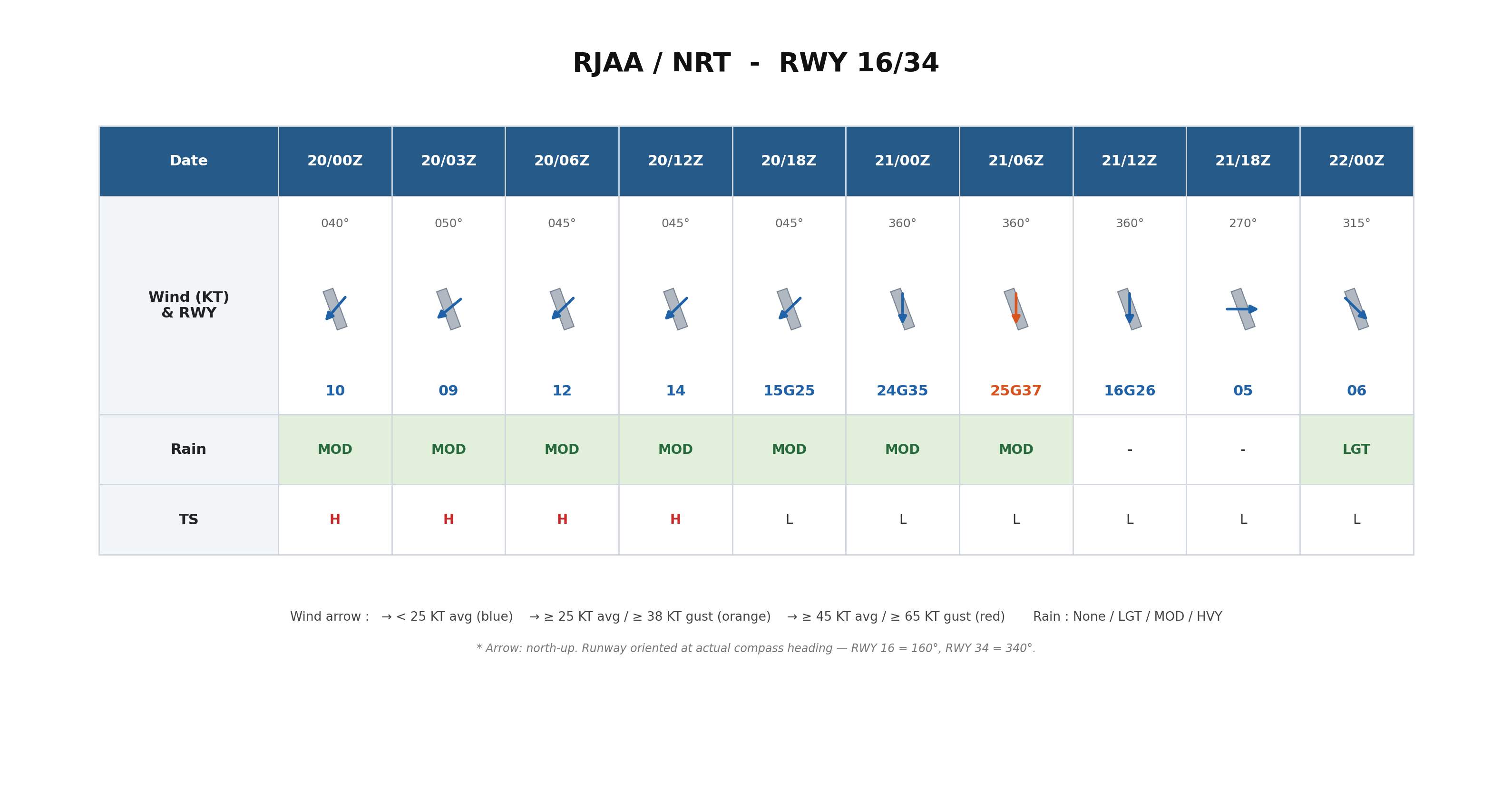
Moderate rain is anticipated to persist at Narita Airport from September 20 through September 21, with a high likelihood of thunderstorms. Winds are expected to peak during the daytime on September 21 at around 25 kt. However, winds are forecast to diminish to below 16 kt after 12Z(UTC) on September 21, with typhoon impacts gradually subsiding.
Haneda International Airport (RJTT / HND) Forecast
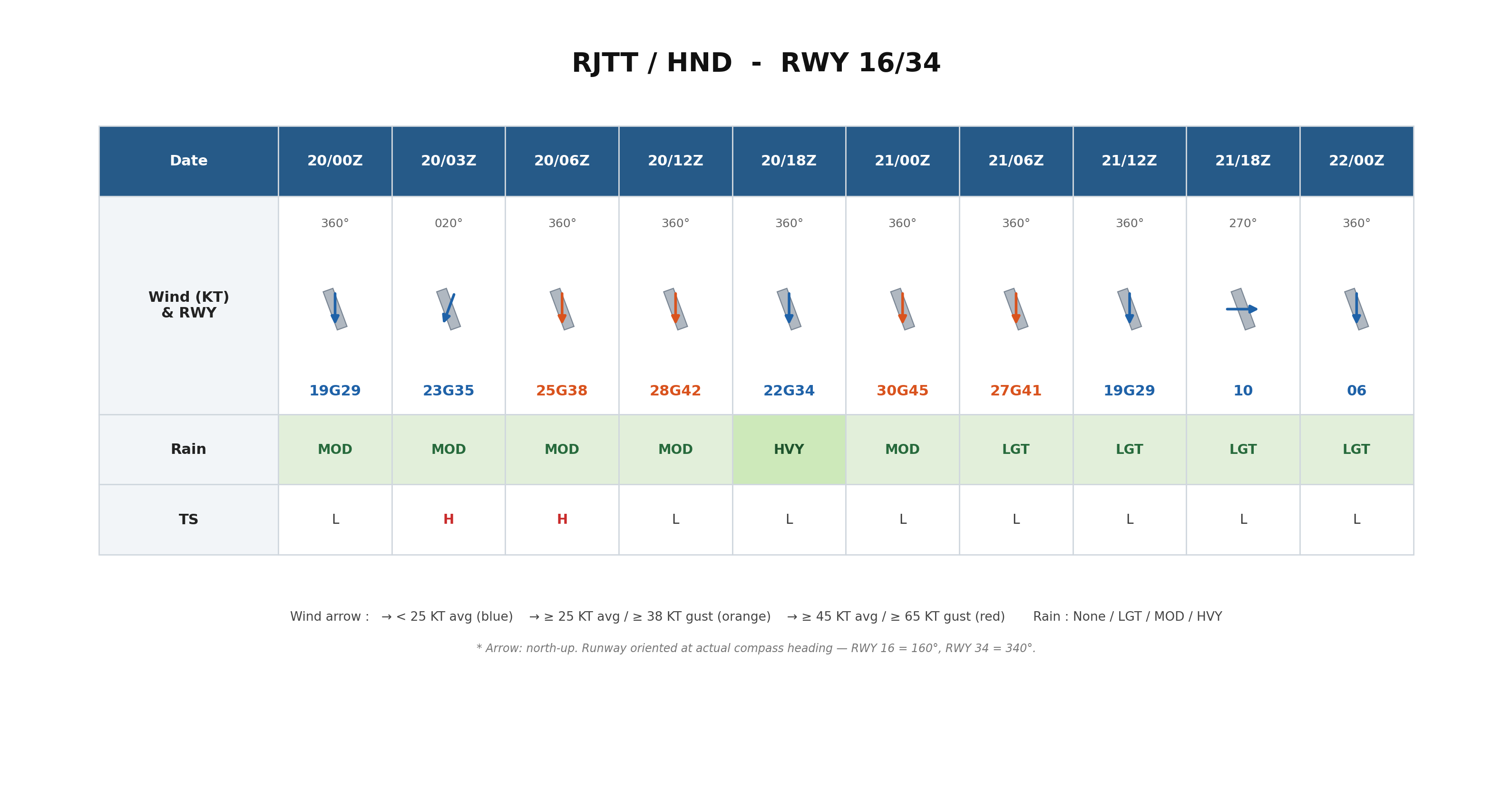
Moderate rain is expected to continue at Haneda Airport from September 20 through September 21. Thunderstorms are highly probable on the afternoon of September 20, and reduced visibility resulting from heavy downpours may occur during the early morning hours of September 21, warranting close attention. Winds are forecast to exceed 20 kt around 03Z(UTC) on September 20, increasing to over 30 kt around 00Z(UTC) on September 21, with maximum gusts reaching up to around 45 kt. Winds are expected to weaken to below 20 kt after 12Z on September 21.
Looking Ahead
Typhoon track, intensity, and wind speed forecasts at the time of closest approach may change. Please continue to monitor the latest typhoon information, airport forecasts, and operational updates.
For more timely and detailed information on typhoons and tropical disturbances, please visit SkyAviators, the aviation decision-support tool for airline operators. Learn more about "SkyAviators"
Disclaimer
This article is provided for informational purposes only. Specific flight operational support is offered exclusively through our dedicated paid services for aviation operators. Weathernews Inc. assumes no liability for operational decisions made based on this article, or for any losses or damages arising therefrom.
![[Tropical Depression] Forecasted to Become Typhoon DUJUAN – Expected to Approach Japan as a "Strong" System](https://gvs.weathernews.jp/wxtech_cms/typhoon25_dujuan_cover_de9913c666.png)