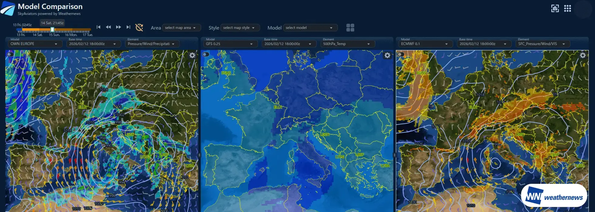
From February 14 to 15, a cold-core low is forecast to track eastward across the northern Mediterranean. Combined with a trailing trough and colder air aloft, the system is expected to bring widespread snowfall to central Europe. Locally heavy snowfall is possible at some airports.
During peak snowfall periods, reduced visibility, lower ceilings, snow-covered surfaces, and deteriorating runway conditions may lead to operational disruptions.
Central Europe Weekend Weather Overview (14–15 Feb 2026)
Snow is forecast at major airports including Zurich (LSZH/ZRH), Munich (EDDM/MUC), Prague (LKPR/PRG), Vienna (LOWW/VIE), and Geneva (LSGG/GVA). In particular, Zurich and Munich airports may see heavy snowfall. However, snowfall amounts and timing remain subject to change depending on the evolution of the cold-core low and the associated cold air aloft.
Meanwhile, at Rome Fiumicino Airport (LIRF/FCO), where the core of the cold-core low is forecast to pass nearby, temperatures are forecast to remain too high for snow. Instead, heavy rain, thunderstorms, and strong southerly winds are forecast, mainly around February 14.
Weather Forecast for Selected Major Airports Expected to Be Affected by Snowfall
| Airport | Zurich Airport | Munich Airport | Prague Airport | Vienna Airport | Geneva Airport |
|---|---|---|---|---|---|
| City / Country | Zurich, Switzerland | Munich, Germany | Prague, Czech Republic | Vienna, Austria | Geneva, Switzerland |
| ICAO/IATA | LSZH/ZRH | EDDM/MUC | LKPR/PRG | LOWW/VIE | LSGG/GVA |
| Snow Timing | from 0900 UTC 14 Feb to 1200 UTC 15 Feb | from 1500 UTC 14 Feb to 1200 UTC 15 Feb | from 1500 UTC 14 Feb to 0900 UTC 15 Feb | from 1800 UTC 14 Feb to 1200 UTC 15 Feb | from 0600 UTC 14 Feb to 1200 UTC 15 Feb |
| Peak Snowfall Period | from 1800 UTC 14 Feb to 0000 UTC 15 Feb | from 1800 UTC 14 Feb to 0000 UTC 15 Feb | from 1500 UTC 14 Feb to 2100 UTC 14 Feb | from 0000 UTC 15 Feb to 0600 UTC 15 Feb | from 1200 UTC 14 Feb to 1800 UTC 14 Feb |
| Low VIS / CIG due to Snow Period | from 1800 UTC 14 Feb to 0000 UTC 15 Feb | from 1800 UTC 14 Feb to 0000 UTC 15 Feb | from 1500 UTC 14 Feb to 2100 UTC 14 Feb | from 0000 UTC 15 Feb to 0600 UTC 15 Feb | from 1200 UTC 14 Feb to 1800 UTC 14 Feb |
| Forecast Snowfall Amount (by 1200 UTC 15 Feb) | 10–15 cm | 10–15 cm | 5–10 cm | 5–10 cm | 3–5 cm |
| Strong Winds ≥ 20 kt | NIL | NIL | NIL | from 0800 UTC 15 Feb to 1200 UTC 15 Feb | NIL |
| Minimum Temperature During Snowfall | -3℃ (from 0500 UTC 15 Feb to 0700 UTC 15 Feb) | -4℃ (from 0600 UTC 15 Feb to 0900 UTC 15 Feb) | -5℃ (from 0500 UTC 15 Feb to 0800 UTC 15 Feb) | -2℃ (from 0600 UTC 15 Feb to 1000 UTC 15 Feb) | -3℃ (from 0100 UTC 15 Feb to 0500 UTC 15 Feb) |
Airline Operational Challenges — Why Do “Unexpected Cancellations” Happen?
Large-scale flight cancellations during winter are often not the result of unforeseen weather. Instead, they often come down to a critical challenge: how to assess forecast reliability within limited decision-making time.
・Even after reviewing the TAF, confidence in the forecast may remain uncertain. ・Numerical weather prediction models can provide additional support, but it is often unclear which model should be prioritized. ・There is little time to check historical performance or consistency across multiple models. ・In operational aviation meteorology, the ability to instantly compare, evaluate, and interpret multiple sources of information has become more essential than ever.
What airlines truly need is a simple, intuitive indicator that allows them to quickly and confidently answer one key question:How reliable is the forecast for this airport?