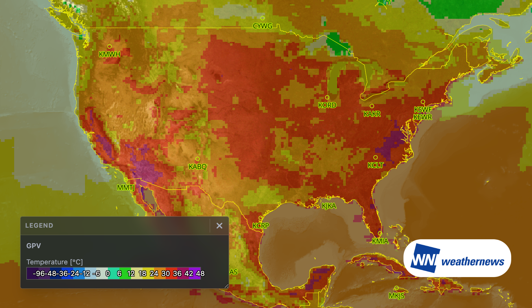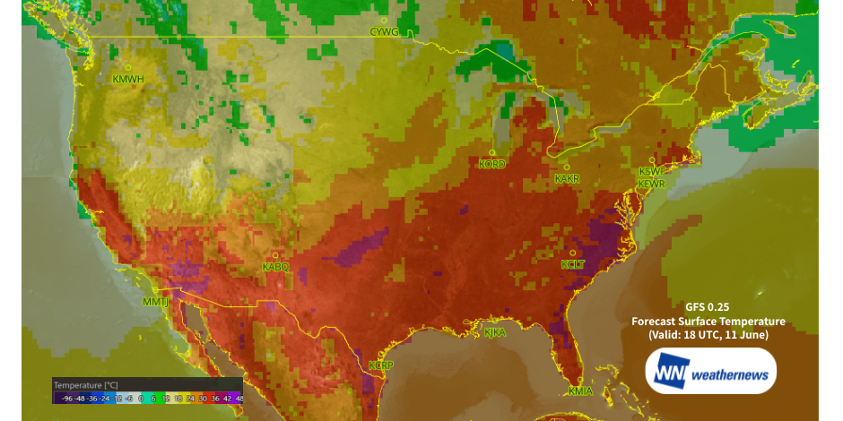
A widespread heat wave—the first of the summer season—is forecast across the Central and Eastern United States during the second week of June. High temperatures may have some impact on airport operations across the affected region.
Meteorological Background
Through June 12, the Central and Eastern US will experience a mix of upper-level ridging and troughing (at the 500 hPa level). With an influx of a warm air mass (18–24°C at 850 hPa), days dominated by the ridge will see intense solar heating, causing surface temperatures to soar. Conversely, on days influenced by the trough, warm, moist air drawn from the south into surface low-pressure systems will also promote warming. However, the timing of any rainfall on these days could help keep maximum temperatures in check.
Heat Wave Progression and Potential Impacts
Meteorological models indicate that the heat wave will peak between June 9 and June 12. The most severe heat will initially target the Central US. from June 9 to June 10, before shifting eastward heading into the weekend. In the Eastern US, anomalous heat may linger through around June 15.
Impact on Aviation Operations
As a general rule, higher outside air temperatures lead to lower air density, which reduces takeoff thrust and, consequently, maximum allowable takeoff weight. Cooler temperatures provide much better margins for takeoff performance.
However, once temperatures climb into the upper 30s Celsius (above 36°C), this degradation in performance becomes exponentially steeper. For aircraft and routes already operating near their maximum takeoff weight under normal conditions, soaring temperatures become a critical operational bottleneck. Extreme heat waves threaten to disrupt a significantly broader range of aircraft types and routes.
Airports must remain vigilant against potential decreases in operational efficiency driven by extreme heat.
Temperature Forecasts for Major Airports (June 9–12) vs. Historical Records
Central US
| Airport | ICAO / IATA | June 9 Forecast High | June 10 Forecast High | June 11 Forecast High | June 12 Forecast High | Highest June Temp & Year (2020–2025 METAR) | Average June Max Temp (2020–2025 METAR) |
|---|---|---|---|---|---|---|---|
| Memphis International Airport | KMEM / MEM | 34℃ | 34℃ | 33℃ | 33℃ | 38℃ (2022) | 35.3℃ |
| Louisville Muhammad Ali International Airport | KSDF / SDF | 30℃ | 34℃ | 33℃ | 31℃ | 37℃ (2022) | 35.2℃ |
| Chicago O'Hare International Airport | KORD / ORD | 32℃ | 36℃ | 31℃ | 27℃ | 37℃ (2022) | 34.5℃ |
Eastern US
| Airport | ICAO / IATA | June 9 Forecast High | June 10 Forecast High | June 11 Forecast High | June 12 Forecast High | Highest June Temp & Year (2020–2025 METAR) | Average June Max Temp (2020–2025 METAR) |
|---|---|---|---|---|---|---|---|
| John F. Kennedy International Airport | KJFK / JFK | 25℃ | 25℃ | 33℃ | 30℃ | 39℃ (2025) | 33.0℃ |
| Newark Liberty International Airport | KEWR / EWR | 29℃ | 27℃ | 33℃ | 33℃ | 39℃ (2021, 2025) | 36.0℃ |
| Washington Dulles International Airport | KIAD / IAD | 29℃ | 33℃ | 36℃ | 37℃ | 37℃ (2024) | 35.7℃ |
| Charlotte Douglas International Airport | KCLT / CLT | 28℃ | 33℃ | 35℃ | 37℃ | 38℃ (2022, 2025) | 35.2℃ |
Note: The exact timing and spatial extent of this heat wave may change as forecasts are updated. Please monitor the latest weather advisories.